National Water Center, Eureka Springs, Arkansas

National Water Center, Eureka Springs, AR
Updated: April 2014 Contact: Contact: NWC
Contents ©1999-2014 by National Water Center. All rights reserved worldwide.
WaterWorks Journal, volume 5, MM
(press here to return to full Table of Contents)
h 2 oh! the more you know
An Atlas of Bryant Creek and Its Watershed
Peter Callaway
Mapping YOUR Watershed
Aleasha Dees & Michael Flitter
Page 44 & 45
An Atlas of Bryant Creek and Its Watershed
by Peter Callaway
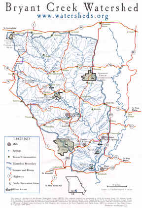
Bryant Creek, a 45-mile-long tributary of the White River in Missouri, begins in lower Wright County, flows through Douglas County, and then ends in Ozark County as it joins the North Fork of the White River at Norfolk Lake. Its watershed includes about 400,00 mostly forested and agricultural acres, and about 8500 inhabitants.
The Bryant Watershed Project began in the spring of 1996 when four or five of us began asking what we could do to preserve and improve the water quality and scenic amenities of the Bryant. We were interested because we live along it or its tributaries, love it. swim in it, endue it. What could a few people do for the Bryant?
 We quickly realized that this was a complex question, and, whatever, we had both to take a comprehensive view by looking at the whole of the watershed, and also to focus our limited time, energy, and resources (provided by an interested donor). What could we do?
What we decided was to learn as much as we could about the Bryant and its watershed: Create an inventory of all the resources, natural and human, in the watershed; Find out all the facts. Then, we might have a better idea of what to do and where to focus. This is a big order, and although it is possible to find lots of information about the Bryant, it’s hard to know where to begin, where to stop, and also, probably as important, how to organize all this information. No question, we had to use computers.
One of us had the idea that it might be interesting to put our information on the Web, so that people could learn more about their watershed. That idea led to the idea of an on-line atlas, since an atlas-type format seemed the best way to organize the information by connecting facts to maps and pictures. So, that’s what we’re doing.
The people in our watershed tend to be somewhat conservative; they always have been and that’s the culture here. They don’t like government intrusion; they don’t like “environmentalists” telling them what should be (or even what “is”). This is not so different from a lot of places; America is basically a conservative country because people came here to get away from countries where they were under somebody’s thumb, politically, economically culturally, or religiously (or all four). So we Americans want to be independent and do our own thing in our own places, getting together as we, not somebody else, chooses.
Mapping YOUR Watershed
by Aleasha Dees & Michael Flitter
Your community may be small or large, spread out or close together. It can be your neighborhood, your block, your city, or your town. The members of your group might all be from the same community, or you might be from different communities. You can define what your community is for this project.
How To Draw the Outline of YOUR Watershed
1. Place the clear sheet of plastic over the topographic map and tack both onto the cardboard.
2. On the topographic map, find and mark your community.
3. Find the streams, ditches, marshes, lakes, oceans or rivers closest to the community site and mark them in blue.
If runoff flows primarily through street gutters and storm sewers, there may not be a stream near by or within your community. However, water flowing underground through pipes must eventually drain into a body of water. If this is the case you may want to contact a city government official about how this system handles the runoff in your community.
4. Use the contour lines and numbers on the topographic map to find the highest and lowest points around your community site. Mark the hilltops (places where contour lines form circles) with an “X”.
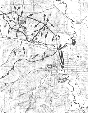
5. From these “X’s” draw arrows on map to show the flow of runoff. Which direction will rain or snow that falls on your community site flow” Where does runoff flow into water bodies?
Think like water! Water always flows downhill. It always takes the easiest path. If you go outside and look or walk down hill from your community site - never going up — you will come to a water body sooner or later. Remember, it may flow underground in pipes. Look for openings where water enters the storm drains.
6. On your map, find the highest ground (the hills and ridges) between two water bodies. Draw a line along the highest points (connecting the hilltops) completely around your stream, including its bottom end or “mouth.” What is the name of the water body that drains your community sites’ watershed.
Completed
Watershed
Map
Page 46 & 47

Go to: the last drop

Scroll down to see individual titles in this section.